-

hand down
-
-
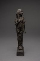
Full-length standing allegorical figure of a woman whose lower portion is in mummy wrappings, and top portion is draped in ancient Egyptian apparel. It is a reduced version of a sculpture designed for the America's Making pageant held in New York in October 1921. Incised at the back of the base: "MVW Fuller" and a copyright symbol
-
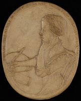
Oval toned plaster plaque reproducing in low relief an engraved portrait of African American poet Phillis Wheatley used as the frontispiece of Wheatley's Poems on Various Subjects, Religious and Moral (London: Printed for A. Bell, bookseller, Aldgate; and sold by Messrs. Cox and Berry, King-Street, Boston, 1773). The engraving was made after a portrait attributed to African American slave and artist Scipio Moorhead. As in the engraving, the words "Phillis Wheatley, Negro Servant to Mr. John Wheatley of Boston" appear around the perimeter of the plaque. It is not signed or dated; the attribution to Meta Warrick Fuller was made by Grace Nail Johnson, sister-in-law of the donor.
-
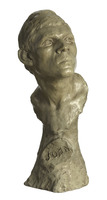
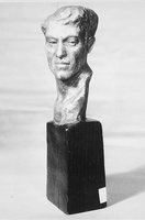
A painted plaster sculpture bust of John the Baptist. The head is turned slightly to the left, with closely cropped hair. The face is alert, with raised chin and open eyes. There is a tall integrated mount and base extending from the bust. It features an oval roundel inscribed with the name "John." The sculpture is painted a light beige.
-
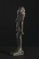
Painted plaster sculpture of a female figure standing with her right hand over her heart, her left arm straight against her side with her hand extended out. Her head is turned over her left shoulder. From the hips down her legs are bound as if mummified. She wears a veil that is draped over her head and falls over her shoulders and down her back. The veil is shaped to resemble a pharaonic headdress. The figure stands on a rectangular, slightly wedge shaped pedestal. The sculpture is painted to look like copper complete with a simulated greenish patina.
-
-

A standing female figure, with her right hand on her chest
-

Sculpture of a horse pulling upward, away from humans seemingly in despair. Green in color.
Scratched on the bottom is the number 2884-1 three times; additional numbers are partially visible.
In the signature only the last name is legible. On the right foot of the horse are the letters MWF inside a rectangle.
-
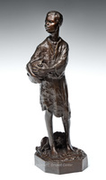
A standing boy holding a water canteen
#1/7
-

A boy leaning forward carrying a water canteen. Another jar is on the ground near his right foot. The reccord indicates edition #1/7, it could be from the donation form, but it is does not appear on the piece. At the bottom on the back, after the signature, on the back right side of base, there is a faint signature, unclear by whom.
-

Portrait bust of John the Baptist - engraved with "JOHN" on the front of the piece. Has a marble base.
-

-
-
-
-
-
-
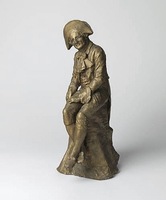
"This is the first important sculpture and the earliest work by Fuller to come to auction. In 1899, the young Ms. Warrick graduated from the Pennsylvania Museum School for Industrial Arts with honors. With a letter of introduction to Henry Ossawa Tanner, she moved to Paris in late October to continue her studies at L'École des Beaux Arts. Fuller befriended Tanner, and received advice and support from the sculptors Augustus Saint-Gaudens and August Rodin. Rodin's sponsorship facilitated an exhibition of 22 sculptures at L'Art Nouveau Gallery in 1902, as well as her inclusion in the Salon of 1903.
Fuller's most famous work, The Awakening of Ethiopia, circa 1910, in the collection of the Schomburg Library and Research Center in Harlem, is considered one of the early symbols of the Harlem Renaissance and among the first American art works to reflect the influence of African sculpture. Benjamin Brawley's 1918 work, The Negro in Literature and Art in the United States, describes her as one of the first artists to explore "the tragedy of the Negro Race in the New World." Brawley mentions Peeping Tom as one of the many early works that did not survive the artist's disastrous studio fire in Philadelphia in 1910. Apparently, it was only missing at the time, or this version was not known to exist. This plaster figure was in the artist's estate when she passed away in 1968.
The Peeping Tom character comes from the legend of Lady Godiva's naked ride through the streets of Coventry. In the tale, the townsfolk agreed not to observe Godiva as she passed by, but Peeping Tom bore a hole in a door to spy on her. According to the legend, he was immediately struck blind. Leininger-Miller pp. 8-9; Campbell p. 177."
Swann Auction Galleries, February 23, 2010
Incised "Meta Vaux Warrick" and dated "99" in the plaster, lower right.
-
-
-
-

Test
-

-
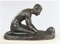
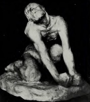
"Sculptor Meta Warrick Fuller's Talking Skull depicts an African man kneeling on the ground contemplating, or addressing a skull. The inspiration for the piece is said to be an African folk tale in which a young man comes across a talking skull. The young man reports his finding to his village and brings the chief to the skull, but it will not talk. In some interpretations, the young man is punished for lying, while in others, the skull later tells the young man "You talk too much!"
Other interpretations of the sculpture suggest it represents the desire for communication between the living and the dead or the African American longing for connection to an African ancestral past." Museum of African American History website


